A new machine learning system can create height maps of urban environments from a single synthetic aperture radar (SAR) image, potentially accelerating disaster planning and response.
Aerospace engineers at the University of the Bundeswehr in Munich claim their SAR2Height framework is the first to provide complete—if not perfect—three-dimensional city maps from a single SAR satellite.
When an earthquake devastates a city, information can be in short supply. With basic services disrupted, it can difficult to assess how much damage occurred or where the need for humanitarian aid is greatest.
“Being able to produce 3D from SAR alone would be really be a revolution.” —Carl Pucci, EO59
Aerial surveys using laser ranging lidar systems provide the gold standard for 3D mapping, but such systems are expensive to buy and operate, even without the added logistical difficulties of a major disaster.
Remote sensing is another option but optical satellite images are next to useless if the area is obscured by clouds or smoke.
Synthetic aperture radar, on the other hand, works day or night, whatever the weather. SAR is an active sensor that uses the reflections of signals beamed from a satellite towards the Earth’s surface—the “synthetic aperture” part comes from the radar using the satellite’s own motion to mimic a larger antenna, to capture reflected signals with relatively long wavelengths. There are dozens of governmental and commercial SAR satellites orbiting the planet, and many can be tasked to image new locations in a matter of hours.
However, SAR imagery is still inherently two-dimensional, and can be even trickier to interpret than photographs. This is partly due to an effect called radar layover where undamaged buildings appear to be toppling towards the sensor.
“Height is a super complex topic in itself,” says Michael Schmitt, a professor at the University of the Bundeswehr. “There are a million definitions of what height is, and turning a satellite image into a meaningful height in a meaningful world geometry is a very complicated endeavor.”
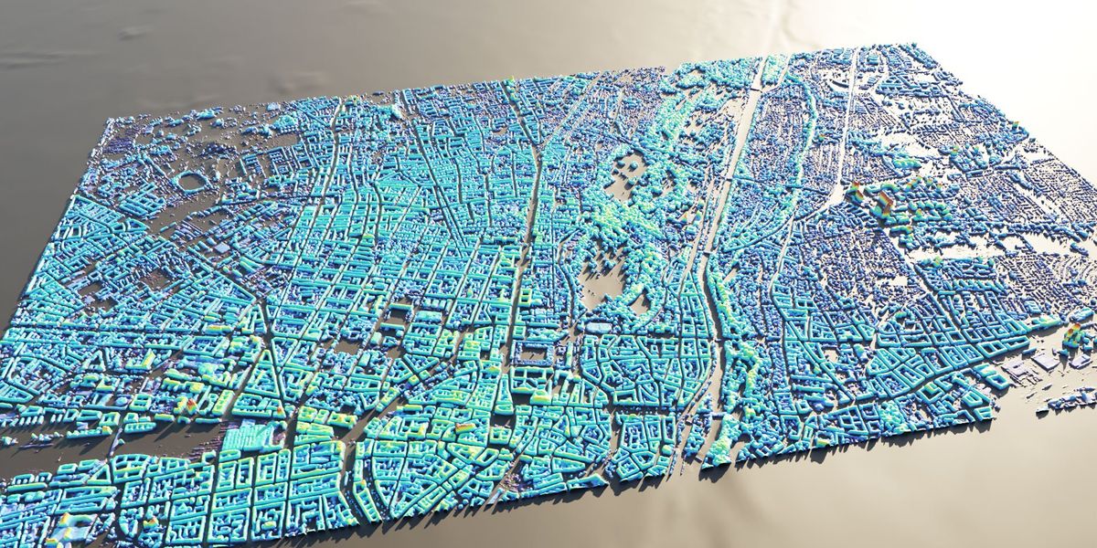
Schmitt and his colleague Michael Reclastarted by sourcing SAR images for 51 cities from the TerraSAR-X satellite, a partnership between the public German Aerospace Center and the private contractor Airbus Defence and Space.
The researchers then obtained high quality height maps for the same cities, mostly generated by lidar surveys but some by planes or drones carrying stereo cameras. The next step was to make a one-to-one, pixel-to-pixel mapping between the height maps and the SAR images on which they could train a deep neural network.
The results were amazing, says Schmitt. “We trained our model purely on TerraSAR-X imagery but out of the box, it works quite well on imagery from other commercial satellites.” He says the model, which takes only minutes to run, can predict the height of buildings in SAR images with an accuracy of around three meters—the height of a single story…
Read full article: AI Generates 3D City Maps From Single Radar Images
The post “AI Generates 3D City Maps From Single Radar Images” by Mark Harris was published on 04/04/2024 by spectrum.ieee.org