This article is part of our exclusive IEEE Journal Watch series in partnership with IEEE Xplore.
During the summer of 2020, China’s second-largest freshwater body of water—Dongting Lake—experienced unprecedented levels of flooding, the likes of which had not been seen over the previous two decades. As a result of unusually high volumes of rainfall, these floods and others throughout the country that summer took at least 141 lives and caused upwards of US$8 billion in infrastructural damage.
And while devastating floods like this are on the rise in a world of mounting climate change, technology used to detect, monitor, and predict flooding is lagging behind. Ground-gathered data can lead to time-delayed and inaccurate mapping—but of course is often more reliable. So remote-sensing data from satellites should be able to supplement what ground-truths cannot deliver in time or at wide enough scales. The problem, however, is that satellite data today still faces challenges from cloud cover and dataset noise.
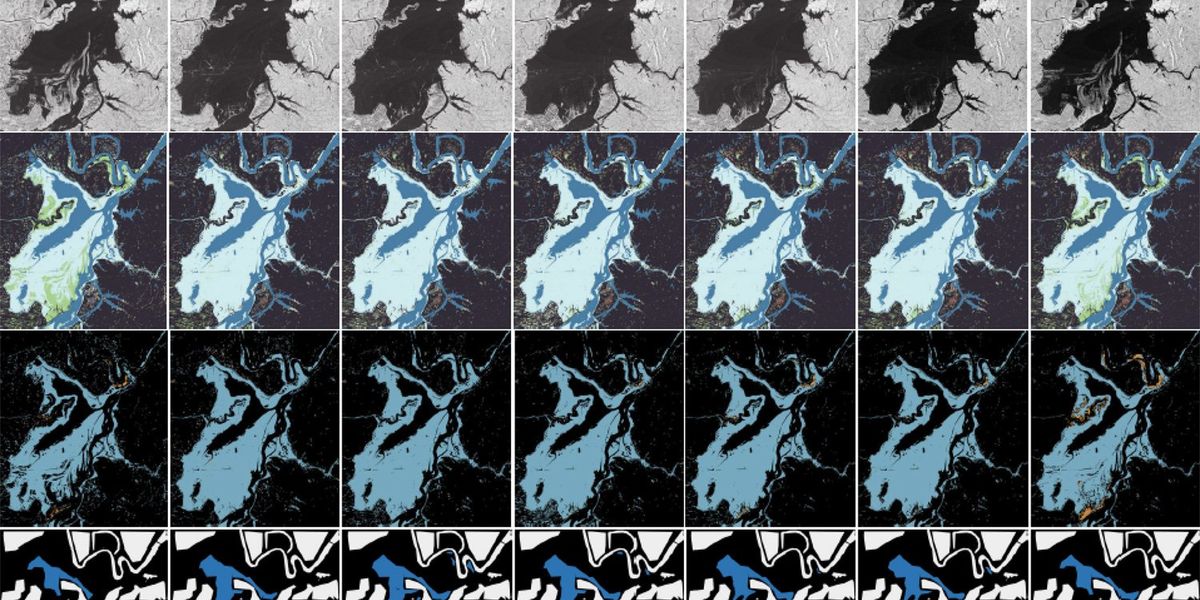
So a team of researchers located only a few hours south of Dongting Lake at Hunan University in China has reported a new approach to monitoring flood regions using time-series synthetic aperture radar (SAR) images and “fuzzy logic” feature detection.
Xinxin Liu is a coauthor on the paper and an associate professor of electrical and information engineering at Hunan University. She says that part of the problem faced by existing SAR flood models is they’re not designed to accommodate how data changes over days or months. This includes important features like backscatter values, which represent information about ground objects like vegetation.
“The backscatter characteristics of radar signals are very complex,” Liu says. “In the same flood event, similar backscatter values may represent flooded or non-flooded areas on different flood days. Thus, it is difficult to achieve accurate flood mapping by using only spatial or limited temporal information.”
Liu and colleagues have worked to address this problem by looking at SAR data over a yearlong time period to help identify specific flood patterns, such as when flood waters typically rise or recede. They combined this time-series approach with feature extraction using fuzzy logic to help choose features from both spatial and temporal domains.
“The proposed method has good consistency and stability in mapping the development of flood events, [and] it can also identify flood regions that are prone to misidentification or omission thanks to time-series modeling,” Liu says. “What’s more, in the case of limited or lack of data, the existing historical multi-temporal dataset can be reused to evaluate the current flood event, broadening the application scenarios of the proposed methods.”
Liu says that this method can be used to help restore areas damaged by floods, as well as create rapid flood mapping during an ongoing flood event.
To put this method to the test, Liu and colleagues…
Read full article: When Waters Rise, Satellites Now Lag

The post “When Waters Rise, Satellites Now Lag” by Sarah Wells was published on 12/07/2023 by spectrum.ieee.org


