

El Niño is here, and forecasters warn that it’s likely to be bigger and stronger in 2026-27 than any El Niño event recorded in at least 150 years.
During strong El Niños, global air and ocean temperatures spike, and precipitation patterns shift dramatically – flooding rains deluge places that are normally dry, and drought strikes some of the wettest locations on earth. With this El Niño arriving on top of already high global ocean and air temperatures, it carries the potential for extraordinary impacts to millions of lives throughout the world. Globally, August 2026 was the hottest month on record, according to data from Europe’s Copernicus climate service.
Those effects are already showing up in Central and South America.
Enrique Ortiz/AFP via Getty Images
Fishing crews in Ecuador are catching fewer tuna and traveling farther from shore to find them as fish migrate to cooler water. Coral reefs are under alert for severe risk of bleaching in many areas.
In Panama, where I live, seabirds common to Ecuador and Peru known as blue-footed boobies began showing up in large numbers in Panama earlier than usual as the sardines and anchovies they eat moved northward to escape the El Niño ocean heat.
Farmers in some regions of Panama have been unable to plant their crops. And many people here are worried about access to drinking water in the coming dry season, normally January to April but predicted to arrive at least a month earlier than usual.

Bernard Gagnon via Wikimedia Commons, CC BY
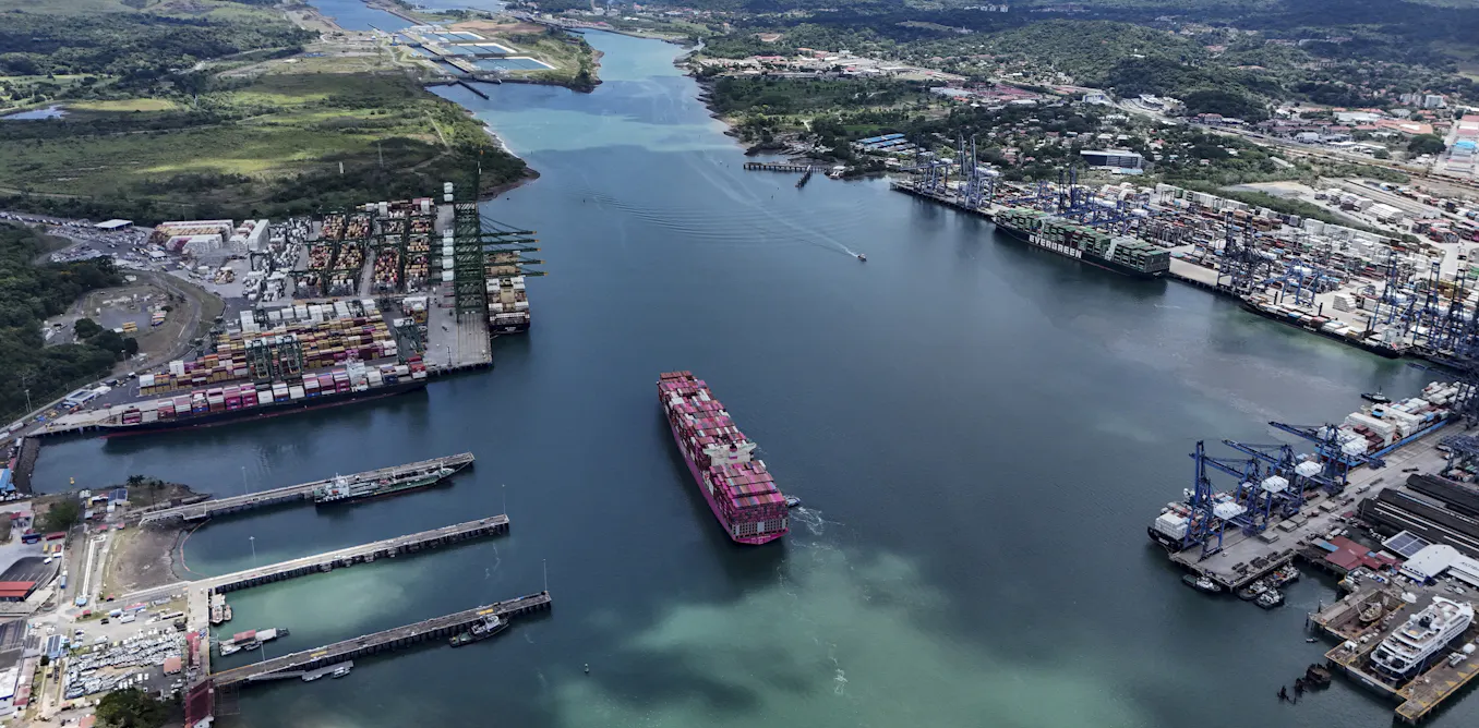
The global economy is also beginning to see far-reaching effects. Worsening drought is reducing the amount of water needed to operate the Panama Canal, resulting in fewer ships with less cargo able to pass through in a day. That leads to higher transit costs for shippers of all kinds of products and slower deliveries.
I am a biologist who has been monitoring the weather in Panama and surrounding regions for the Smithsonian Tropical Research Institute for almost 40 years. That includes major climatic events such as El Niño, and what I am seeing in Panama in 2026 in terms of heat and drought has already begun to exceed anything that we have measured here in over a century.
What is El Niño?
El Niño is a naturally occurring phenomenon that can affect weather around the world. Its origin lies in the tropical belt of the Pacific Ocean.
Normally, trade winds along the equator blow from east to west in this region, pushing warm surface water toward the islands of southeast Asia, where it accumulates.
The first sign that El Niño is developing is a weakening, or even reversal, of the tropical Pacific trade winds. Without the winds, warm water in the east begins to flow back and eventually occupies much of the equatorial waters down to about 300 meters from the coast of South America to the middle of the Pacific.
That shift sets off a chain of changes in weather patterns around the world.
What can El Niño do to – or for – you?
According to predictions from the National Oceanic and Atmospheric Administration (NOAA), as well as many other national and international climate authorities, the earth and its inhabitants can expect one of the warmest, if not the hottest, years on record both in 2026 and 2027.
Global ocean temperatures are already at record highs, raising concerns about the compounding effects of El Niño and global warming effects on corals and other sea life, particularly along the west coast of the Americas and Australia.

Climate Reanalyzer, Climate Change Institute, University of Maine, CC BY
Some of the wettest regions on the planet, including southeast Asia, Australia, northern South America, Central America and the Caribbean, are expected to experience severe droughts this year.
Places that are normally extremely dry, such as the coasts of Ecuador and Peru, may face strong storms with the potential for life-threatening floods.
Why it’s hard to forecast El Niño and its effects
The El Niño-Southern Oscillation – the climate system that swings between warm El Niño and cooler La Niña conditions every few years – like many things in nature, is extremely complex. Scientists have been studying it for generations, and many things about it are still not fully understood.
Forecasters, such as NOAA, use many different computer models to help predict how complex systems like this will unfold. Each model differs in the details of how they make their predictions, and the average of the models forms the basis of the predictions presented to the public.
It is important to understand that these are best estimates based on the available knowledge and understanding.
Every El Niño is different. They can vary significantly between one event and another both in timing and impact. Each El Niño seems to include some unexpected results, especially regarding where droughts and floods appear. Some effects, such as drought in Central America and global air temperature spikes, are almost guaranteed. Others, such as heavy rainfall on the U.S. West Coast, are more variable. For example, the 2015-16 El Niño, one of the strongest on record, brought little relief to drought-stricken California.
So, do not assume that what usually happens at your location during El Niño will happen this time.
The super, mega El Niño of 2026-27
To gauge the intensity of an El Niño event, scientists look at the temperatures in the middle of the equatorial Pacific in a region known as Niño 3.4.
The intensity of an El Niño event is defined as the current or expected sea surface temperatures in that region minus the long-term average. A very strong event is considered to have a value of at least 2 Celsius – meaning it’s 2 degrees Celsius (3.6 degrees Fahrenheit) warmer than the average.
In the past century, two El Niño events stand out – 1982-83 and 2015-16 – each with values close to 2.6 C (4.7 F).
Predictions for the current event include from around 3 C to almost 4 C (5.4 – 7.2 F), potentially placing it well above anything that has occurred in at least 150 years, and likely much longer.
This matters to the global economy
The influences of El Niño should raise global alarms for economies as well.
The Panama Canal is one of the world’s most important shipping choke points, particularly for ships traveling to and from the U.S. It relies exclusively on fresh water from rivers pouring into Lake Gatun to operate its system of locks, which act like elevators – filling with water to lift each ship 85 feet (26 meters) from sea level to the lake and then back down to sea level on the other side. The canal saves days of travel time and hundreds of thousands of dollars in fuel costs as ships travel between the Atlantic and Pacific oceans.
Panama is normally so rainy that the locks can function at full capacity throughout the year. During droughts, however, the lake levels can begin to fall even during the rainy season when they should be going up.
Once lake levels are no longer safe for the largest ships to pass, the Panama Canal Authority, the agency in charge of the canal, begins to restrict their maximum draft, meaning how deep into the water the ships sink when loaded. Even before then, it starts to reduce the number of ships that can pass each day in order to save water.
Previous major El Niños have resulted in significant interruptions to the canal’s operations. This year is no exception. The Panama Canal Authority has already begun to restrict the number and size of ships allowed to pass in 2026. As El Niño intensifies, these limits will only become tighter.
As what could be the strongest El Niño on record develops, families, communities and economies need to prepare. Local areas may see more intense effects than expected, or they may see different effects than in past El Niños. The best preparation is to be ready for the worst and pay attention to the forecasts.
The post “2026’s El Niño is shaping up to be a doozy – it’s already affecting global shipping, fish behavior and heat” by Steven Paton, Research Biologist, Smithsonian Tropical Research Institute, Smithsonian Institution was published on 09/10/2026 by theconversation.com